The exponential growth in global population, mainly concentrated in urban areas, has led to an increase of the so-called “mega cities”, often located in hazard-prone areas (e.g. Mexico City, Tokyo, Los Angeles). These settlements frequently rely upon the interconnections and interactions between many networks. In the event of an earthquake, a failure of one of these networks may cause a cascading effect, leading to the failure of others. This interdependency has been indicated as one of the reasons for the increase in the global economic losses due to disasters in the last decade.
Mitigation and preparedness actions can have a paramount role in lowering the extent of the damages and improving the performance of the networks, for example, Orion’s electricity company following the 2011 Christchurch earthquake. This company, which spent about 6 million NZD since 1996 in a seismic strengthening programme, estimated to have saved about 60 million NZD in direct repair damage. The figure below illustrates the contrast between the levels of damage registered in two substations (located approximately 500 meters apart), resulting from the fact that only the one on the right was seismically strengthened prior to the Christchurch earthquake.

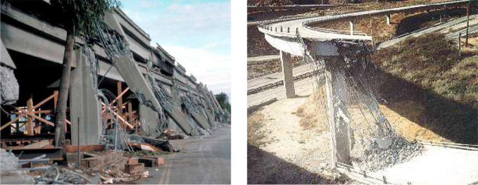
Within the various types of lifelines, transportation networks are fundamental for social and economic development. Moreover, in the aftermath of a seismic earthquake event, not only are transportation networks fundamental in the response phase, but they are also fundamental in the long-term when it comes to recovery and reconstruction efforts. Several past events have highlighted the vulnerability of transportation networks to earthquakes. After the 1989 Loma Prieta earthquake, 142 roads had to be closed in the San Francisco Bay Area. Five years later, a similar number of roads were affected due to the 1994 Northridge earthquake. The potential indirect losses due to the disruption of the economy in the surrounding areas as a result of such closures can easily exceed the repair and reconstruction costs. The figures below illustrate the extent of the damage in the transportation network observed after these two seismic events.
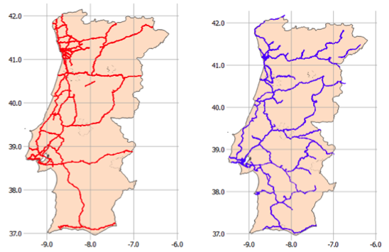
The assessment of damage or disruption potential of these networks can support the creation of risk reduction strategies, such as the one endorsed in Christchurch. In this context, GEM has developed an open-source framework for earthquake scenario analysis of spatially distributed networks, supported by the OpenQuake-engine. This framework is capable of calculating a number of metrics (e.g. probability of collapse, probability of disruption, repair time, indirect losses) considering specific earthquake scenarios or probabilistic seismic hazard. The usefulness of this platform is demonstrated through a case study for a mining industry in the South of Portugal. This particular business utilizes the railway and highway networks in order to function. The location of roads, railways, bridges, viaducts and tunnels were extracted from the OpenStreetMap initiative, as depicted in the figure below.
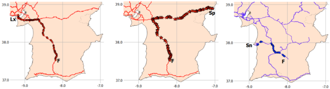
For their mining activities, this factory (F) imports materials which can arrive either from Lisbon (path Lx-F) or Spain (path Sp-F) through the highway network. Then, the products of this factory are exported using the railway network to the port near the town of Sines (path Sn-F), where they are shipped to different locations around the world. The critical paths used by this factory are identified in the figure below.
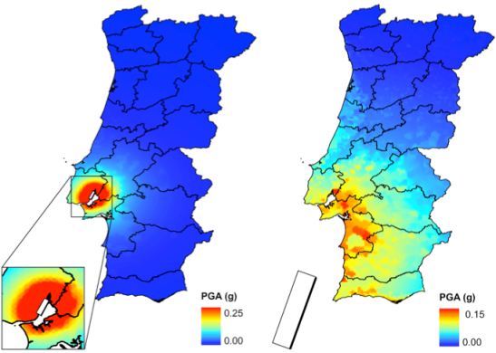
Two earthquake scenarios have been defined to evaluate the impact that damages in these networks may cause to the mining factory. The first scenario is located in the Tagus Valley near Lisbon, and it has a magnitude of 5.7 (Mw). The second scenario is located offshore, and it has a greater magnitude (7.6 Mw). The location of the rupture surfaces and the distribution of the mean peak ground acceleration (in g) are illustrated in the figure below. The ground shaking input was combined with sets of fragility functions to calculate the expected damage in the bridges and viaducts composing each path. Then, the damage distribution was employed to calculate the expected repair time and probability of disruption.
The two scenarios produced distinct consequences for the factory. The onshore event only led to significant damage for the path between the factory and Lisbon (Lx-F), with a probability of disruption of nearly 75%, and a repair time of 175 days. However, due to the possibility of importing the necessary materials from Spain, this event does not cause a significant threat to this business. On the other hand, the offshore scenario caused a probability of disruption of 32%, 20% and 7%, for the Lisbon, Spain and Sines paths, respectively. These results imply that there would be a 20% probability that the importation activities would be interrupted, and a 7% probability that it would not be possible to export the products out of the factory. Moreover, the repair times of these critical paths were estimated in 48 days for the connection to Spain and 16 days for the path to Sines. Such downtimes would certainly lead to heavy losses to this company, and even impact the local economy.
These results indicate that, in certain cases, although a certain business may not suffer direct damages due to the occurrence of a seismic event, it may suffer important economic losses due to its reliance on the transportation network. It also highlights the importance of having alternative paths for material supply and for exportation, in order to increase its resilience to earthquake activity. These analyses may also be useful to identify the parts of a given network that are contributing the most to the disruption probability, and thus where retrofitting campaigns should be prioritised.
For more information about these tools or models, please contact us at integrated_risk@globalquakemodel.org.
